Is It Really Possible to Sight the African Coast from Sardinia?
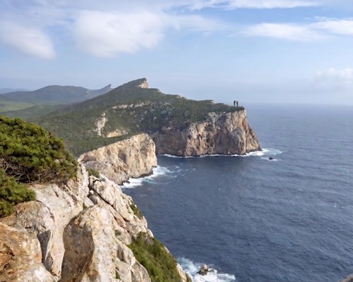
Standing on the cliffs of Capo Teulada—the southernmost tip of Sardinia—you look across the open Mediterranean toward Tunisia. Separated by roughly 185 to 200 kilometers of open water, local maritime lore has long claimed that on exceptionally clear, crisp winter days, one can make out the distant contours of North Africa.
The Physics: Geometry, Earth’s Curvature, and Atmospheric Optics
To determine whether the sighting is physically possible, we have to look at the geometry of the Earth’s curvature alongside optical atmospheric behavior.
1. Geometric Line of Sight
The distance to the geometric horizon d(in kilometers) from an elevation h (in meters) accounting for standard terrestrial atmospheric refraction is approximated by:
d approx 3.86 sqrt h
-
Observer Height (Capo Teulada): The promontory rises to approximately 220 meters above sea level.
d observer approx 3.86 sqrt 220approx 57.3 km
-
Target Elevation (Tunisian Mountains): Low-lying beaches around Bizerte or Cap Serrat remain hidden well below the horizon. However, northern Tunisia features prominent peaks, such as Djebel Ichkeul (~511 m), Djebel Abiod, and further inland Djebel Zaghouan (1,295 m). For a peak of 500 meters:
d_target \approx 3.86 sqrt500 approx 86.3km -
Combined Theoretical Range: 57.3 + 86.3 = 143.6 km. Under standard conditions, a 500 m peak at 190 km remains geometrically concealed beneath the sea’s horizon bulge.
For the tallest peak in the region, Djebel Zaghouan (1,295 m, situated ~240 km away):
d_target approx 3.86 sqrt 1295 approx 138.9 km implies Total Reach approx 196.2km
2. Atmospheric Refraction & The “Looming” Effect
Standard geometry assumes an average atmospheric temperature gradient. However, Mediterranean winter conditions frequently produce temperature inversions (a layer of cold, dense air trapped directly above the sea with warmer air above it).
This inversion creates a steep refractive index gradient that bends light rays downward along the curvature of the Earth—an optical phenomenon known as looming (or an extreme superior mirage / Fata Morgana).
-
The Verdict: You cannot see the African beaches or coastline, but under strong thermal inversion conditions with low humidity (often following a dry Mistral/Tramontana wind clearing coastal aerosol haze), the silhouette of northern Tunisia’s highest mountain ridges can be projected above the horizon.
A Crossroads of Conflict, Trade, and Melting Pots
Whether observed directly or simply navigated by dead reckoning, this narrow marine gap turned southern Sardinia and North Africa into a continuous corridor of cultural and military exchange.
┌───────────────────────────────┐ │ Capo Teulada / Sulcis │ └──────────────┬────────────────┘ │ ~185 km │ Trade, Invasions, Mediterranean Sea │ Corsairs & Migration │ ┌──────────────┴────────────────┐ │ Tunisian Coast / Tabarka│ └───────────────────────────────┘Phoenician & Punic Dominance
Because the crossing took less than two days of favorable sailing, Phoenician and Carthaginian traders established foundational emporia along Sardinia’s southern shores:
-
Nora, Sulky (Sant’Antioco), and Tharros served as twin hubs to Carthage.
-
During the Punic Wars, Sardinia acted as both a staging ground and a fiercely contested agricultural breadbasket between Rome and North Africa.
The Vandal Conquest & Early Medieval Exiles
After the fall of the Western Roman Empire in the 5th century AD, the Vandals seized Carthage and used their North African fleet to capture Sardinia. During this era, North African Catholic bishops (including Saint Fulgentius of Ruspe) were exiled to Sardinia, bringing with them manuscripts, theological traditions, and monastic networks that linked the two lands.
Barbary Corsairs and the Coastal Watchtowers
From the 16th to the 18th centuries, the short crossing made southern Sardinia prime territory for raids by North African corsairs operating out of Tunis, Bizerte, and Algiers.
-
To counter sudden raids, the Spanish Crown constructed a defensive perimeter of over 100 coastal watchtowers (Torri costiere) around Sardinia’s perimeter—including the tower at Capo Teulada—to signal incoming sails via smoke and fire.
The Tabarchino Phenomenon
One of the most concrete examples of this human connection is the story of the Tabarchini:
-
In the 1530s, Ligurian coral fishers settled on the small island of Tabarka off the northern coast of Tunisia.
-
Facing political pressure and enslavement in the 18th century, King Charles Emmanuel III granted them refuge on the island of San Pietro off southwestern Sardinia, where they founded Carloforte in 1738.
-
To this day, the population retains a unique Ligurian-Tunisian hybrid dialect (Tabarchino), traditional North African couscous culinary roots (Cascà), and architectural styles shaped by centuries on the African coast.